SprayLogger™ Pesticide Application Mapping Software
Less Desk Time, More Spray Time!
SprayLogger is advanced pesticide application mapping software that helps professional applicators track, manage, and report every spray job. Monitor spraying in real time while capturing essential details including GPS location, spray width, weather conditions, chemical usage, applicator activity, and equipment information. Use live mapping to view completed spray areas, generate automated pesticide application reports, support regulatory compliance, and export spray data to GIS systems. Whether you operate large spray rigs, ATVs, UTVs, drones, or backpack sprayers, SprayLogger helps save time, improve accuracy, and maintain reliable spray records.

Map it right, every spray...
SprayLogger leads the way!
Pesticide Recordkeeping Made Simple
Spray in the field while SprayLogger automatically maps, logs, and organizes the details you need for reports, compliance, and GIS exports.
Spray
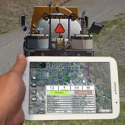
Start a job from your mobile device and begin applying with your truck, ATV, UTV, backpack sprayer, or other spray rig. View your location and activity in real time as you spray.
Auto Log & Save
SprayLogger records and automatically synchronizes location, acreage, distance, weather, applicator, equipment, chemical details, and spray/no-spray activity to your private account as you work.
Report & Share
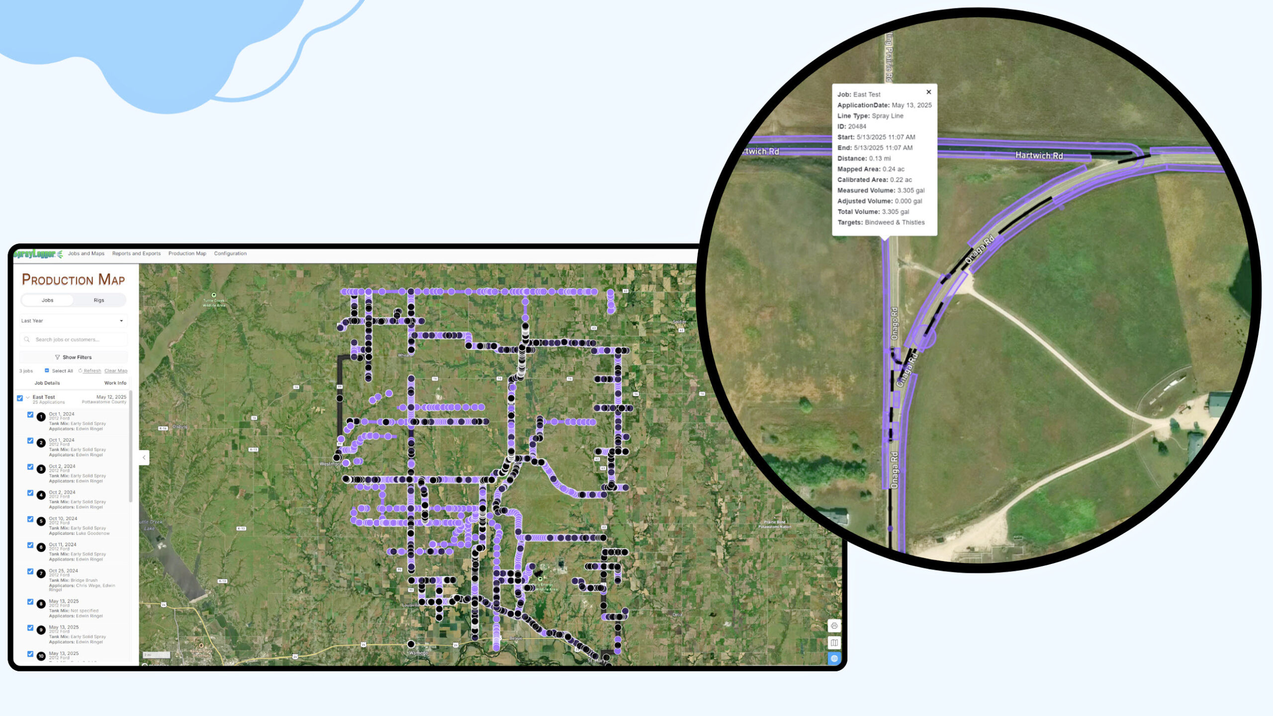
Access all your spray jobs for the entire year via the web. Generate professional maps and reports, and export data for use in any GIS and other database and reporting applications.
Watch our video to learn how SprayLogger delivers more spray time and less desk time.
Pesticide Application Mapping Software for Reporting and Compliance
Accurately Track, Report and Export Every Application
Real-Time Tracking
Monitor spray and no-spray operations on a live moving map.
Works Offline
Capture every spray detail with or without an internet connection.
Detailed Reports
Printable maps and reports are generated for every job.
Seamless GIS Export
Export any or all jobs to any GIS (shapefile or KMZ supported).
Custom Map Layers
Include custom map layers like parcel boundaries for detailed reference.
Any Spray Rig
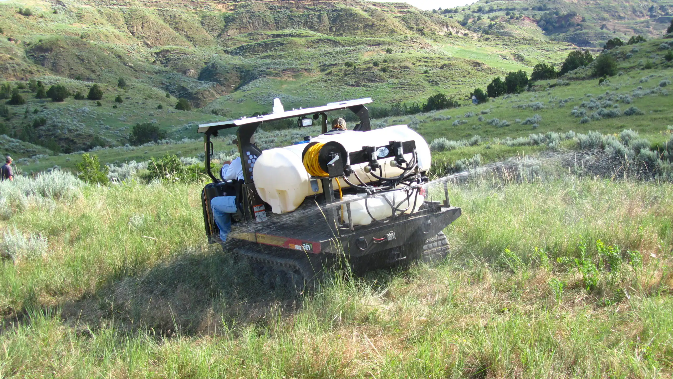
SprayLogger units available for backpacks, drones, UTV, truck and rail.
Pesticide Application Mapping Software Built for Professional Applicators
EVERY POSSIBLE SPRAY DETAIL captured for detailed reports
AUTOMATED WEATHER information from the nearest station
GIS EXPORT to any shapefile or KMZ supported software
SUB-METER GPS with ActionMapper data loggers
WFS SERVICES deliver real time viewing in other GIS software
COST REPORTING for invoicing or internal use
AUDIBLE SPRAY ALERTS to help avoid no-spray areas
RAPID JOB START- answer 5 questions or less to start a job
AREA & DISTANCE calculations for spray and no-spray areas
BUILT-IN MAPS including satellite, street and topographic
CUSTOM LAYERS overlay your own maps over other GIS data
SUMMARY REPORTS for details on a single or multiple jobs
MULTIPLE APPLICATIONS by one or more applicators on one job
MULTIPLE SPRAY SECTIONS including width, up to 12 booms
MULTIPLE FLOW SENSORS- 1% accuracy on up to 4 tanks
SECURE, CLOUD-BASED access, storage, security and backup
PROVEN with over 13 years on public and private jobs
FREE onboarding and technical assistance
Pesticide Application Mapping for Any Spray Rig
Because not all spray jobs use the same equipment


SPRAYLOGGER FAQs
Questions about pesticide application mapping, compliance records, reports, weather and equipment activity.
What makes SprayLogger different from other pesticide recordkeeping systems?
SprayLogger is built for professional spray operations that need more than basic spray notes or manual recordkeeping. It combines GPS spray mapping, chemical tracking, applicator records, job details, weather information, reporting, and compliance documentation in one connected system.
Instead of relying on paper forms, spreadsheets, or disconnected apps, SprayLogger helps crews automatically map and document where spraying occurred, what was applied, who did the work, and when it happened.
What platform does SprayLogger operate on?
SprayLogger operates on AgTerra’s connected field data platform, combining MapItFast mobile mapping, Strider Forms, ActionMapper datalogging hardware, and web-based reporting tools. This gives spray operations one integrated system for mapping applications, collecting pesticide records, tracking chemical use, syncing field data, and generating professional reports.
Does SprayLogger work on iOS devices?
Not at this time. SprayLogger is an extension of AgTerra’s MapItFast mobile platform, which is available from both the Google Play Store and Apple App Store. However, the SprayLogger mobile workflow is currently supported only on Android devices.
For best performance, SprayLogger requires an Android device running Android 11 or newer. Support for iOS devices is planned for a future release.
How does SprayLogger help reduce office work?
SprayLogger captures spray activity in the field and turns it into usable maps, records and reports with far less manual data entry. Spray lines, no-spray areas, job details, chemical use, applicator information, and other required records can be collected during the job instead of recreated later at a desk.
For managers, this means less time chasing paperwork, correcting missing information, or building reports from scratch. The result is better documentation, faster reporting, and more confidence in the accuracy of every spray record.
Who is SprayLogger best suited for?
SprayLogger is best suited for vegetation management companies, weed and pest districts, applicators, agencies, utilities, contractors, and other organizations that need reliable pesticide application records.
It is especially valuable for operations that manage multiple applicators, spray rigs, jobs, customers, or treatment areas. SprayLogger helps document work clearly, stay organized, support compliance, and maintain long-term records of pesticide applications.
Does SprayLogger automatically map where spraying and no-spraying occurred?
Yes. SprayLogger can map spray activity as work is being performed, helping applicators and managers clearly document treated areas. When paired with ActionMapper hardware, SprayLogger can capture GPS-based spray and no-spray activity from the equipment, reducing the need for manual drawing or after-the-fact record reconstruction.
Can SprayLogger help with pesticide compliance records?
Yes. SprayLogger is designed to help organizations maintain clear, organized pesticide application records. It can document key details such as treatment location, date, applicator, equipment, chemical products, application rates, weather information, and job-specific notes.
This helps reduce missing information and makes it easier to generate records when needed for customers, internal review, audits, or regulatory documentation.
How does SprayLogger help managers oversee multiple applicators or spray rigs?
SprayLogger provides managers with a unified, real-time view of spray operations across crews, equipment, jobs, and timeframes. Through the online Production Map, managers can monitor mapped spray activity, chemical usage, applicator logs, and related job details for multiple applicators in one place.
Can SprayLogger track chemical use?
Yes — SprayLogger tracks specific chemical use from a tank mix by job, applicator, spray rig, customer, or time period, so you can see how much was applied, where, and at what cost.
The system’s chemical-use summary reports support planning, billing, inventory checks, compliance documentation, and year‑end reporting.
What types of equipment can SprayLogger be used with?
SprayLogger can support a wide range of spray operations, including large spray rigs, UTVs, ATVs, backpacks, drones, and other equipment setups. It is especially powerful when used with ActionMapper datalogging hardware, which helps automate spray activity mapping from the equipment itself.
This flexibility makes SprayLogger useful for both large and small scale vegetation management operations with multiple types of equipment.
Does SprayLogger work in remote areas with poor cell service?
Yes. SprayLogger is designed for field conditions where connectivity may be limited. Applicators can collect spray records in the field and data automatically syncs when service becomes available.
This is important for roadside, rangeland, utility corridor, agricultural, forestry, and other remote treatment work where connectivity is often unavailable or limited.
Can SprayLogger document no-spray areas or sensitive zones?
Yes. SprayLogger can help document both spray and no-spray activity. This is useful when crews need to show where treatment occurred, where it did not occur, and how they handled sensitive areas such as waterways, crops, property boundaries, restricted zones, or customer-defined exclusions.
Good no-spray documentation can be especially valuable for accountability, customer communication, and risk management.
Can SprayLogger generate reports?
Yes. SprayLogger can help generate professional pesticide application reports from the data collected in the field. Reports can include mapped treatment areas, chemical details, applicator information, weather data, dates, job details, and other application records.
This reduces time spent building reports manually and helps create more consistent documentation across the organization.
Can SprayLogger show other applicators’ jobs in real time?
SprayLogger allows authorized users to view other applicators’ jobs in real time. Permitted users can monitor one or multiple jobs at once through SprayLogger’s Production Map feature, which is accessible from any internet browser. In addition, users can view other applicators’ current locations in the MapItFast mobile app when location sharing is enabled. Historic spray jobs can also be viewed as a layer in MapItFast, giving applicators visibility into where previous applications occurred. Real-time visibility depends on cellular or internet connectivity; when crews are outside coverage, job data is stored locally and synced once a connection is restored.
How is SprayLogger different from paper forms or spreadsheets?
Paper forms and spreadsheets require applicators or office staff to manually record, transfer, organize, and verify spray information. SprayLogger streamlines that process by connecting field mapping, chemical records, job details, and reporting in one system.
The result is fewer missing details, less duplicate entry, better maps, faster reporting, and more reliable long-term records.
Why should a spray operation choose SprayLogger?
A spray operation should choose SprayLogger when it needs accurate spray maps, better pesticide records, easier reporting, and stronger oversight of field work. SprayLogger helps connect what happens in the field with the records managers need in the office.
For organizations that care about compliance, accountability, efficiency, and long-term treatment history, SprayLogger provides a more complete solution than basic recordkeeping tools.

“While there are other capable systems on the market, SprayLogger combines an extremely easy to use platform with powerful maps, reports and data I can actually use.”
Real Person Support
Our knowledgeable support staff is just a call or email away for help with setup, troubleshooting, or optimizing your spray tracking
Training and Workshops
Empower your team with expert-led training sessions tailored to your needs. Virtual and in-person training is available.
Technical Support
AgTerra offers prompt assistance from a real person during business hours, Monday through Friday. Reach out to our dedicated support team whenever you need help!
Online Support
Access our extensive online help library with detailed documents and videos 24 hours a day.
Consultation & Development Services
Your success is our priority. We assist you in fully leveraging and enhancing the mapping, spray tracking, and reporting capabilities of SprayLogger.