The First Steps
In the search for solutions to simplify field data collection, AgTerra came across a product that merged both traditional and futuristic data collection in what looked like a fairly ordinary pen. This pen marked the beginning of a data collection solution dubbed WriteTEQ. Specialized pens were used with paper forms printed with “microdots,” tiny dots indiscernible to the naked eye. Users would fill out forms and then place the pen in a dock at the end of the day where the data would be transferred to a computer.
While exciting in concept, WriteTEQ posed some challenges for field users and office employees alike. The data transfer process did not always go smoothly and what data did come through required additional verification to ensure that all handwriting was accurately converted to digital format. These downfalls, paired with the expense of costly pens and fees involved with licensing, led to the eventual phasing out of WriteTEQ.
Mapping a Better Way
Field surveys and observations in agriculture and natural resources are nearly always associated to an object that can be mapped, such as a field boundary, roadway, or the location of a new weed. But electronic mapping can be data-intensive and difficult for many people to learn. Understanding its importance in the industry and the demand for easy-to-use tools, AgTerra began developing its own mapping software in the late 2000s and launched the release of MapItFast in 2012. MapItFast made it possible to use a single tap to GPS the locations of objects onto a map.
At the same time, a better way to collect attributes or data on mapped objects to upload into databases was needed. WriteTEQ developments were re-purposed to mobile devices and Strider, the forms and reporting system customers know today, was born. AgTerra continues to develop these core products alongside the rapidly-changing landscape of mobile and cloud-based data collection. Developments include seamless data syncing across web and mobile devices, emailable and printable PDF reports, GIS and tabular data export options, REST API support for third party databases, and integrated datalogging hardware. For the field user, it all starts with “One Tap to Map”!

SprayLogger: A Game Changer for Pesticide Record-keeping
Before long, AgTerra found its customer base growing from solely ag-based clients to other businesses and agencies working in the natural resource industry. Pesticide applicators found MapItFast particularly suitable for weed mapping but wondered if there might be any way to automate spray application mapping and records automated on spray rig operations. AgTerra’s developers accepted the challenge and introduced SprayLogger as a record-keeping system specifically for weed and pest applicators.
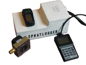
SprayLogger uniquely combined hardware and software and gave pesticide applicators a way to simplify digital record-keeping and accountability for their yearly spray jobs. The early SprayLogger boxes were large and cumbersome to install; requiring several additional accessories to work correctly. Applicators had to use a special keypad for entering applicator, tank mix and target pest information and a separate GPS unit to gather location data. When a spray job was completed, applicators used a “data shuttle” to manually transfer spray jobs to the computer.
While the technology wasn’t perfect, weed and pest operations soon discovered SprayLogger added a whole new level of capability to their operations, reducing tedious record-keeping and allowing more time for spraying. “More Spray Time and Less Desk Time!” It didn’t take long for word to spread across Wyoming, neighboring states, and eventually across the US as well as Canada.
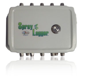
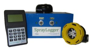
Increased demand lead to improvements to the system. The SprayLogger system has had numerous improvements since it first made its debut in 2009. Some notable enhancements include the ability to automatically sync spray data to a cloud-based database, ability to map and record multiple booms, and a more streamlined box and integration with MapItFast and Strider. The full list of improvements is simply too long to list here! Check out all the features on on current E3B model.
Today, SprayLogger works on any spray rig on the market today, from trucks, ATVs, hy-rail equipment and even backpacks. See this comparison chart for more information on SnapMapper, FoggerLogger, and Backpack Lite.

We Couldn't Have Done This Without You
 From the beginning, our mission has been to provide our customers with powerful, affordable, efficient solutions for mapping and data collection while focusing on ease of use and delivering extraordinary customer service. None of this would have been possible without the relationship we have built with our customers and the feedback we receive.
To all of our customers, thank you for working with us. We wouldn’t be where we are today without you. For those of you who are not yet part of the AgTerra story, give us a call. We can’t wait to hear from you.
Get the most advanced pesticide record keeping system on the market.
Call AgTerra TODAY to get started at (307) 673-1050.
For well over a decade AgTerra has enabled natural resource professionals to simplify data collection and reporting while delivering greater value to their customers. How can we help you? Contact us today for a FREE demo and let us help you learn how easy and affordable our technology can be for your workforce and operations.
